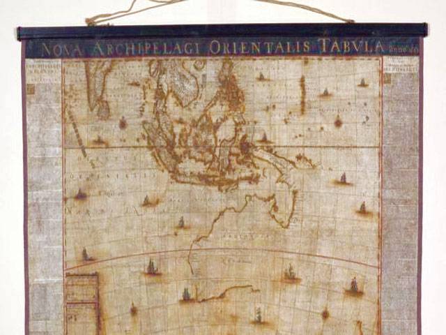
Sydney-A rare 17th Century map of Australia, one of just two left, has been found in an attic. Created in 1659 by renowned Dutch cartographer Joan Blaeu, the unique map was thought to have been lost forever. Archipelagus Orientalis (Eastern Archipelago), as it was called, was unearthed in 2010 in storage in Sweden after 350 years.
It has gone on show at Australia’s National Library, its permanent home.
It is believed that the treasure was buried away when a 1950s antique bookseller who owned a stockpile of books and maps went out of business.
The owners, whose identity is unknown, only realised the rarity of the map when it was sold at auction.
“I think someone stumbled onto a treasure,” the library’s curator of maps, Dr Martin Woods, told news.com.au. The National Library of Australia acquired it for an estimated price of AU $600,000 (£350,000; $450,000) in 2013 and, after a few years of restoration, it is now on display in the library’s Treasures Gallery until mid-2018. The map is based on a sighting of Tasmania by Abel Tasman’s crew aboard the Zeehaen in 1642, the library says. It was the most current reflection of Australia at the time of its creation before the template was changed when Captain Cook explored the east coast in 1770.
Like most maps, it is likely to have been originally used as a decorative piece or a diplomatic gift.