WASHINGTON-Nasa’s fleet of hurricane-hunting satellites could be fully operational as early as next year.
The space agency is currently testing a new system that uses eight mini-satellites to better predict the power of deadly storms long before they strike land.
Current tracking technology is adept at forecasting the path of hurricanes, but lacks the capacity to accurately gauge their intensity. Nasa’s fleet – known as the Cyclone Global Navigation Satellite System (Cygnss) – could plug this gap, helping scientists advise people in the path of a storm whether they need to evacuate their homes. ‘The fact that we have a much better understanding of where these storms are going to go is a great first step,’ Steve Bowen, a meteorologist for insurer Aon Benfield’s Impact Forecasting team and who is not involved in the Nasa project, told Reuters.
‘We sort of have half the circle filled in, and we need to get that other half filled in, which is that intensity component.’
While the science of tracking a storm relies heavily on data about conditions on its periphery, predicting power, or intensity, relies on finding where its energy is coming from by measuring what is happening in the middle of it.
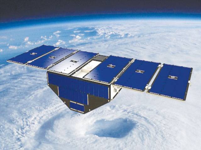
Typically, that means flying a hurricane hunter aircraft inside the storm, measuring wind speeds from a weather buoy as a storm passes overhead or relying on satellites that may fly over once every other day. The $157 million (£118 million) Cygnss constellation was designed to measure surface winds in and near the inner core of tropical systems.
The low-orbit system reads winds at the outer edge of a storm’s eye, a region where most of its power is generated.
Modern satellites systems often struggle to penetrate this area due to heavy rains that are often generated around the eye.
Each of the Cygnss low-orbit spacecraft weighs just 64 pounds (24kg), with a 5-foot (1.5-metre) wingspan.
They measure storm winds using GPS signals reflected by the ocean surface, which are able to penetrate through the intense rain found in the wall at the eye of the storm.
With Cygnss satellites passing over more often, and being in a position closer to the storms, it will offer real-time data to be plugged into intensity models, Nasa said.
The entire system could be fully operational as early as next year, researchers said.
At present, researchers are focusing on the 2017 season when hurricanes devastated Texas, Florida and Puerto Rico, causing hundreds of billions of dollars in damage.
They are replaying data gathered from Cygnss to see how it affected the quality of the forecasts and how it can be better used to predict intensity.
Previous satellites, which flew over relatively infrequently, had trouble measuring ocean surface winds at the centre of storms, with their signals often being degraded by heavy rain at the core, Nasa said.
‘For storms that are changing really quickly, you could miss something like rapid intensification,’ said Dr Christopher Ruf, principal investigator for Cygnss and a climate science professor at the University of Michigan.
Measuring the intensity of a hurricane quickly and formulating predictions on its changes is key to giving people on the ground time to prepare.