Pakistan has experienced series of flooding by unprecedented cloudbursts and ravaging rivers from unexpected directions since 2010, a wage of sin for turning a deaf ear to climate change. Besides cloudburst and splitting of glaciated lakes, manmade factors of neglect and greed multiplied such catastrophes. Deforestation, limited drainage capacity of rivers and steep gradients amplify destruction year after year. Changing pattern of monsoons combining with Mediterranean jet stream and high temperatures on both ends produce floods in Pakistan. Abnormally high temperatures in Sindh and Balochistan were a timely indicator that floods were in offing. The attention of Pakistan’s weathermen, hydrologist and water management engineers other than be obedient gatekeepers of spillways has to shift tonew realities. The challenges arenow beyond building a dam on River Indus. Unless the template of Pakistan’s water management and irrigation structure is not re-patterned, there will be loss of life, infrastructure and environment besides water that the country direly needs.
In 2005, Rivers Swat and Panjkora followed by cloudburst in parts of KPK and Punjab created mega flood in North Punjab and Malakand Division. Nullah Leh, Rivers Haro, Korang and Soan spread havoc. In 2010, the pattern shifted further North wreaking destruction in Swat, Nowshera and Charsadda. The shifting of these patterns to Rivers Jhelum, Chenab, Ravi and Sutlej in Indian held Kashmir is consistent. In 2015, the pattern has shifted further North affecting Chitral and Gilgit.
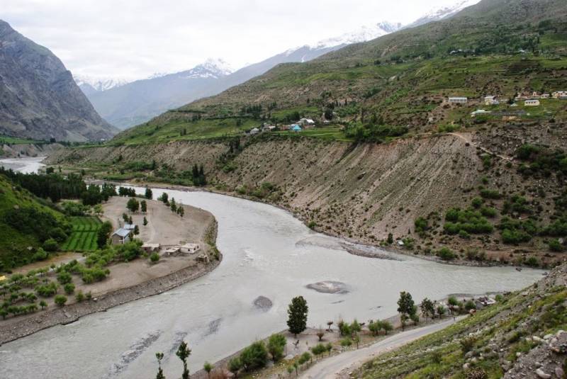
Mountain Rivers in North West Pakistan fed by glaciers and cloudbursts ultimately debouch through River Kabul into Indus. River Indus already in flood is joined by high floods of Jhelum and Chenab, also a result of these climate changesand Run of River dams located in Indian Held Kashmir. India releases excess water from Sutlej and Ravi causing floods besides flooding wide expanses from Haroonabad to Marot, the course of dried up Sarasvati (Nara) River. In Pakistan, Sarasvati follows the course of Hakra, Reini and Nara. Instead of storing this water released by India, Pakistan allows it to wreak havoc, make inundations, cause salinity, and water logging and is eventually wasted into the Arabian Sea.
Pakistan Metrological Department (PMD) had forewarned that the center of Pakistan’s monsoon was gradually shifting from the watershed in Central Punjab with capacity to absorb heavy monsoons, to the northwest and catchment areas of Indus River system in IHK. Unfortunately KPK and FATA neither have the rivers nor canal systems capable of absorbing unprecedented quantities of water. These rivers cascade down through narrow gorges at very high velocity sweeping boulders, manmade infrastructures and causing destruction. A similar phenomena taking place in IHK and catchment areas of DI Khan and DG Khan aggravate the situation. Cloudbursts cause splitting of glaciated lakes to release large amounts of trapped water. Tragedies of Kedarnath in India, IHK in 2014 and Swat are cases in point. Let’s know why this happens.
Due to rising temperatures in Bay of Bengal, the usual stream of monsoons over central Punjab is gradually shifting towards KPK, Gilgit and Gigit. In the past, the Mediterranean jet stream that causes snowfall in the Hindukush and Karakorum bypassed Pakistan. In 2010, it was blocked by a mysterious system over China that diverted it towards Pakistan combining with the shifting pattern from Bengal. Consequently the rainfall area shifted to KPK. According to PMD, columns of rain clouds toweringover 40,000 feet above KPK in comparison to normal clouds around 10,000 feet caused havoc. When rain fell on glaciers, it formed lakes and under this force, glaciers split. Consequently, these clouds dumped an equivalent of two Tarbela dams (12 feet of excess moisture) before they changed course to China. Dr. Hanif Khan of PMD opines that this latitudinal redistribution in the past 25 to 30 years has shifted monsoons from Punjab to Nowshera-Charsadda KPK. This year the pattern has shifted further North to include Chitral and Dir. Pakistan’s water management and the government has been caught napping. In an ironic twist, Pakistan should be indebted to India for at least harnessing some part of this water, lest the scale of tragedy would have been worse. Due to infectious politics, even the thought of building new dams is sacrosanct.
So what is the need?
River Kabul is perennial and spates during monsoons. The quantity of water it dumps into Indus along with right bank tributaries is over 20 MAF, enough to fill the redesigned Kalabagh Gorge to store water and produce over 5000 MW of electricity. In addition run of river dams need to be built over Rivers Chitral, Panjkora and Swat. This will increase the life of Munda Dam on River Swat and also produce electricity. The suggested configuration will add over 8000MW to the national grid. The water needs of Sindh can be met from the new system and compensated from Tarbela without violating the Water Apportionment Accord (WAA) 1991. In fact Sindh is likely to get four times more water that WAA 1991. Construction of Khyber Dam in cooperation with Afghanistan will not only harness raging waters but also produce over 4000MW for people of Afghanistan and Pakistan.
So where does the water from Tarbela go? A new canal like Ghazi Barotha will be diverted to the Soan Depression. With additional tributaries like Soan, Haro and Korang, this dam will have a storage capacity of over 34 MAF of water for South Punjab, holding extra floodwaters that afflict KPK. It will produce more electricity than Tarbela. It can be fed from Tarbela during peak flood seasons for three months. All share of Sind’s water through an exit canal and power plants will flow back into Indus. It can also be connected to Head Rasul through an exit power generating canal.
River Jehlum is a major cause of floods beyond Head Rasul and Taunsa. Construction of Rohtas Dam on Kahan River without affecting storage of Mangla will have the capability to block Jehlum during floods in Indus, Chenab, Ravi and Sutlej. It will have capacity to produce electricity at entry and exit of over 2000 MW. The heritage site of Rohtas Fort will stand like a citadel over the dam. Under the WAA 1991 all water in excess of the apportionment can be stored in this dam for South Punjab. Entire South Punjab will become green, groundwater will be recharged and Rivers Ravi and Sutlej will flow once again.
To be continued…
Written in consultation with Dr. M S Shafiq an Internationally recognised water management expert and Engineer Inam Ur Rehman a Hydrologist from Canada.
samson.sharaf@gmail.com


