Central Hunza and Upper Hunza, or Gojal, were dramatically separated a few years ago, due to a landslide which created the Attabadlake. This is situated about a half-hour drive on the Karakoram Highway (KKH) beyond Karimabad, the capital of the former state of Hunza and main tourist destination. The whole area was, for millennia, very isolated and insular, until the construction of the KKH(1966-74), which leads up to the Khunjerab Pass and beyond to Kashgar, in Western China. Now goods, cars and voyagers are ferried across the jade blue Attabadlake, in about 40 minutes.
The first town in Gojal is Gulmit where, with Chinese assistance, excellent reconstruction work is still going on. It is creditable, indeed, that since this devastating landslide, the Chinese government has been providing food supplies, such as rice and others essentials, to each affected household. In Gulmit, the Raja family operates the spacious Marco Polo Inn. The national sport of the Karakorums, polo, has gradually declined, due to socio-economic reasons and cultural modernity. The polo ground of Gulmit, as that of Karimabad and numerous other villages in Hunza have, in recent times, been converted into children’s playgrounds. It is only in the Chipursan valley, that polo is still played in the original rough style. With almost no rules, the game is played on ancient, narrow grounds. In colonial times the British modified this sport, as may be seen on the polo grounds of Lahore or other international arenas of this Game of Kings and King of Games. Here in Gulmit, the octogenarian Shah Gull, is a genial host, who recounts with pleasure his golden years as the ace of the Hunza polo team. He recalls with pride that the Mir of Hunza gifted him nine outstanding horses and recounts having played with numerous Rajas and Mirs, including the Mirs of Hunza and Nagar and the genial Raja of Khaplu.
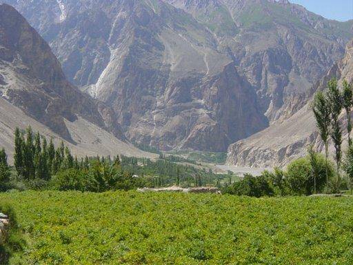
Beyond Gulmit, the carpet smooth KKH winds across Upper Hunza, along numerous streams and rivers and some of the most spectacular granite and Gravel Mountains in the world, which culminate in eternally snow-clad craggy peaks? This is a vast region, home mostly to the 30,000 plus Wakhi people and a few thousand people of Brusho origin. Half-an-hour’s drive from Gulmit, is Passu, famed for its magnificent soaring ‘Cathedral’ with its ever ascending ramparts, towers and gradated rock. This mammoth may, indeed, be compared to the greatest of all medieval cathedrals, at Riems. The ridges and cloudy peaks have been hewn by the elements in geological time and the vast structures of bare, sculpted stone are often spectacularly lit from the west by the setting sun. This area has a sizable ‘chakor’ partridge population, which often strays near the highway at dawn. Besides the Himalayan ibex, these ridges are also home to the peregrine falcon, one of the most dazzling of all birds of prey -smartly dressed in striped stockings and a blue-grey coat - it plummets like lightning down at its quarry from these craggy cliffs.
Described thus by Tennyson:
“He watches from his mountain walls
And like a thunderbolt he falls.”
The Passu area, a vast plateau circumscribed by mountains, is also the confluence of the Hunza, or Gojal, and Shimshal rivers. Passu boasts numerous hotels and is the perfect base for multifarious excursions in the great Karakorams. In one direction is the arduous jeep drive, along some divinely flavoured roadside springs, to the Shimshal valley and region, which culminates laterally along the mountainous border with China. In times past, the Mir of Hunza would send his prisoners to this remote outback. Besides other rare wildlife, this is also a refuge of the prized blue sheep. The Shimshal area is now an increasingly popular tourist attraction, renowned for its lofty grandeur and Pamir trek. Another interesting excursion in the area is Borithlake, a kilometre above the Karakorum highway, just short of Passu. Thisoval shaped, salty, gem-like lake, is dramatically located below some magnificent icy peaks. ‘Bore’ means salt in the Brusho language and this is a popular local attraction, with simple accommodation and friendly service available. These waters are renowned for curing skin ailments and are also a halt for numerous migratory waterfowl, some of the more spectacular of which are the ruddy shelduck, red crested pochard, pintail and shoveller. This area, like various places in Gojal, is also inhabited by the thick-furred snow leopard and hare.
The Borith-Passu area is home to a celebrated mountain juggernaut, including the towering and imposing Sisper Peak at a height of 7611metres, and massive glacial formations like the Passu and Batura glaciers. It is also a base for exploring verdant pastures in various directions. Guides and helpful advice are available at the numerous hotels and inns for venturing into this trekkers’ paradise. Passu is also justly celebrated for its cuisine and sumptuous, richly flavoured apples. Traditional dishes like ‘maulida’ and ‘ghral’ pancakes can be enjoyed here.
About half-an-hour drive beyond Passu, and still travelling along the Gojal River on the KKH, is the lush green village of Khyber. It is now known for well-organised ibex trophy-hunting as well as its delicious peaches and apples. Another half-hour drive leads to the port and frontier town of Sust, situated at an altitude of 2700 metres. Sust also has numerous hotels and restaurants. Further north is the Khunjerab Pass and the Pak-China border. This is at a distance of about 75 km. from Sust and a two hour drive through spectacular, almost treeless mountain ranges, one of which is starkly black. Indeed, Karakoram means ‘Black Mountain’. Here,
from the ‘bam-i- dunya’ or roof of the world, Kashgar is at a distance of 420 kms. And in the opposite direction, Islamabad is 540 kms away. The Karakorum Highway is considered the eighth wonder of the world, and leads beyond the Khunjerab Pass to the ancient town of Kashgar, immortalised in these lines of Iqbal’s poetry (translated):
“One be Muslims from the shores of the Nile to the ends of Kashgar.”
CONNECT WITH US
Picturesque Gojal
ePaper

ePaper - Nawaiwaqt

NIPCO House, 4 - Shaharah e Fatima Jinnah,
Lahore, Pakistan
Tel: +92 42 36367580 | Fax : +92 42 36367005
Nawaiwaqt Group | Copyright © 2024
