
Out amongst the Kirthar Mountains, in the eastern side of Kirthar National Park, in the middle of nowhere, lies Rannikot. Also known as the Great Wall of Sindh and the largest fort in the world, Rannikot is actually a 35km (some estimate 45km) wall encircling the Kirthar Mountains and occupying an area of 65 sq.km. Within the outer walls are other forts: Miri Kot and Sher Garh; Shahper Gate and Mohan Gate. Beyond Mohan Gate can be seen an arid valley and the signs of an ancient road, part of the Barbicon Arachosia, which connected Bhambore to Kandahar; a road used by many a conqueror and traveler of yore.
After traveling 90 km north of Hyderabad on the Indus Highway, you turn left onto a dusty road, till you reach the edge of the national park, the second largest in the country. Drive down further, meandering through rocky mountains and arid terrain and you suddenly get your first glimpse of the wall, snaking its way across the hilltops.


You enter the fort through its eastern Sann Gate. One can clearly see that at some point there must have been a bridge there, spanning a now dry river and connecting the battlements on either side. According to Salman Rashid - writer and traveler – this was the Ranni River, which, at that time (perhaps until 2,000 years ago), was a perennial stream that would turn into a torrential river with the arrival of seasonal rains. It is then that the bridge must have been constructed, indicating its ancient origin.

It is said that parts of the gate (and other areas such as Miri) were renovated by the Talpurs in the 19 century and one can see the difference in the masonry of the ancient structure and the newer one.

However, the Talpurs did not build the entire wall. Although its origins are shrouded in mystery, historians think that the fort was first converted from a garrison to a larger fort, sometime during the Scythian, Parthian, Kushan empires. Perhaps one of these empires started the wall and then the rest added to it, or repeatedly restored it, to defend themselves from other powers.
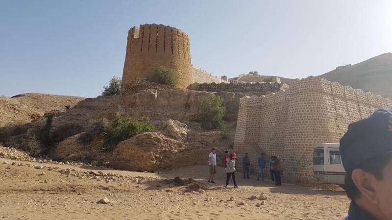
The solid semi-circular bastions are connected to each other by the inclining wall itself and provide a 360 degree view of the surrounding mountains. It is silent and desolate and one wonders what exactly were the builders defending. The wall covers three sides of the whole area, while the remaining northern side is protected by high mountains.

One can climb up from either side of Sann Gate to reach the bastions. The wall is falling apart in some areas, where there is only a precarious platform that can take you to the next bastion.

The smaller Miri Fort is about 3 km away from Sann Gate, sitting on a mound and encompassed by the outer walls. And from Miri, if one looks up in the distance, is Shehrgarh.


The only thing we know about Rannikot is that it is ancient. Travelers, traders and armies visited it or passed by it, some of them leaving behind artifacts (local villagers have found coins similar to the ones from the 15th century). Then the Talpurs came to renovate Sann Gate, Miri and Shahper and build the lofty Shehrgarh. No research has taken place and the earlier attempts to restore parts of it only resulted in further damage. The Endowment Fund Trust, established by the Government of Sindh in 2008, now an independent non-governmental organization, has taken the responsibility of restoring it. One hopes that they will not employ the same degrading methods as those of the Government.
What Rannikot was meant to defend and who actually built it will perhaps always remain a mystery. What can be conjectured is that it was a well-travelled area, which now hides at least 2 millennia of history. Whatever its intended function, one cannot deny that it is glorious, awe inspiring and undeniably fascinating.


